


 215 242

472
●
(MEXICO—1849.)
Plan para la defensa de los estados invadidos por los
bárbaros.
27, [4] pages. 8vo, original printed wrappers, minor wear. Not in Palau, none
known at auction.
México: Ignacio Cumplido, 1849
[300/400]
473
●
(MEXICO—1859.) Lassépas, Ulises Urbano.
De la colonizacion de la Baja
California.
249, [1] pages. Small folio, contemporary
1
/
2
calf, moderate wear; hinges split,
moderate foxing; early owner’s signatures on flyleaf and first page, small inked “MM”
stamps on verso of title and page 52. Palau 132763; Sabin 39137.
México:Vicente García Torres, 1859
[500/750]
474
●
(MEXICO—1865.) Esteva, José María.
Memoria sobre la pesca de la perla
en la Baja California.
3 folding maps. 27 pages. 4to, laid in original blue wrappers,
unbound; minor wear to fore-edge; uncut, unopened. Not in Palau.
México:A. Boix, 1865
[250/350]
475
●
(MEXICO—1884.) Cházari, Estéban.
Piscicultura de agua dulce.
15 folding
plates. [6], lix, [3], 828 pages. Thick 8vo, contemporary
1
/
4
calf, moderate wear; wear to
some plates; inked binder’s stamp on front pastedown, early inscriptions on half-title, early
owner’s embossed stamp on title page. México: Secretaría de Fomento, 1884
[250/350]
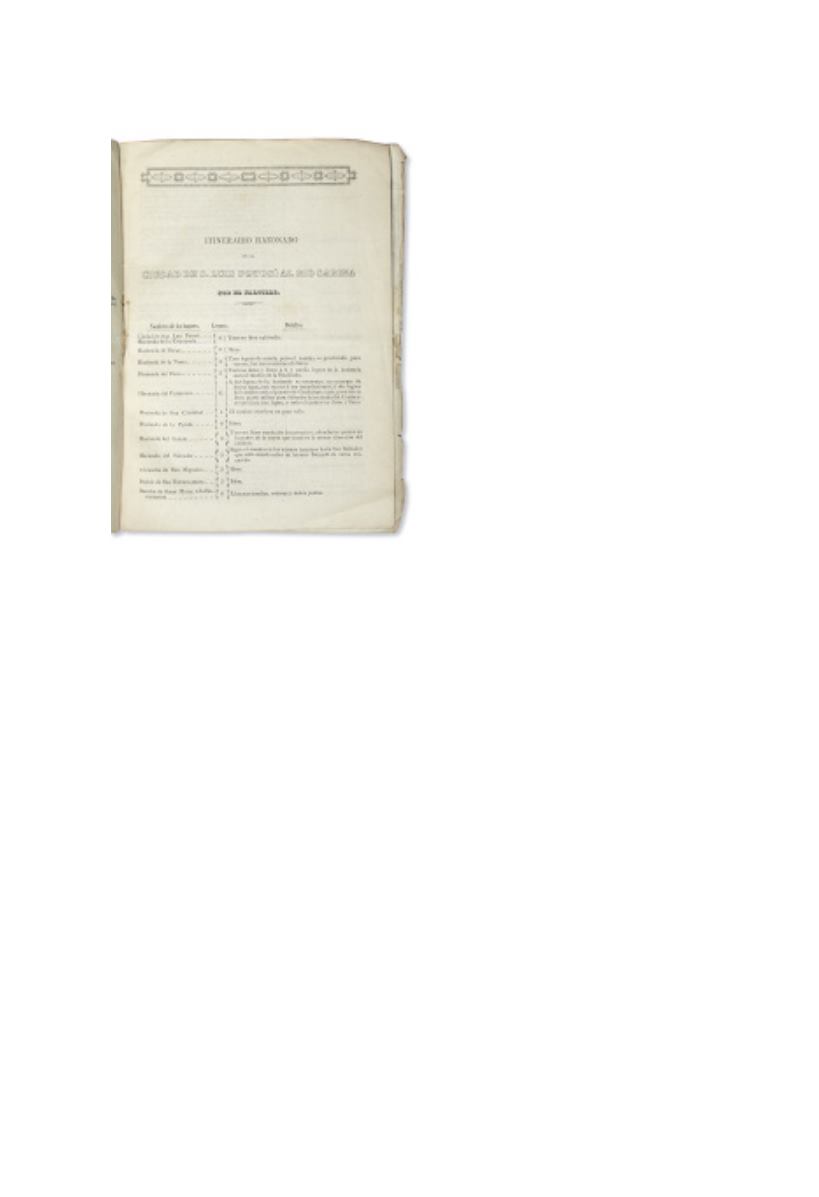
471
●
(MEXICO—1844.)
Colección
de itinerarios para diferentes puntos
de la República Mexicana, formados
por la seccion de geografia y estadística
de la Plana Mayor del Ejército.
28, 9
pages. Folio, original printed wrappers,
moderate wear;a bit dog-eared,minimal foxing.
México: J.M. Lara, 1844
[1,200/1,800]
Of greatest interest is the 9-page appendix
which offers a series of detailed itineraries
between San Luis Potosí and various points in
Texas, accompanied by comments on the state of
the roads. For example, the itinerary from the
Rio Grande to Bejar concludes with comments
on Ciudad San Antonio Bejar: “Camino plano
por un llano llamado de Leon: el paso de este
rio es vadeable en las secas.” Mexico had just
recently invaded Texas in the Mier Expedition,
perhaps explaining why the military prepared
these detailed routes.
The 28-page first section consists entirely on tables
of distances between various cities in Mexico. Palau 56534; Streeter Texas II:1001. No other copies
known at auction.
WITH
—a separately printed double-page itinerary of two short routes from Veracruz
issued by the Seccion de Estadistica Militar, with the facing titles “Itinerario por Leguas de Veracruz a
Orizava” and “Itinerario por Leguas de Veracruz a Perote.” Minor dampstaining and wear; no other
copies traced.