Notes from the Catalogue: John Randel’s Map of New York

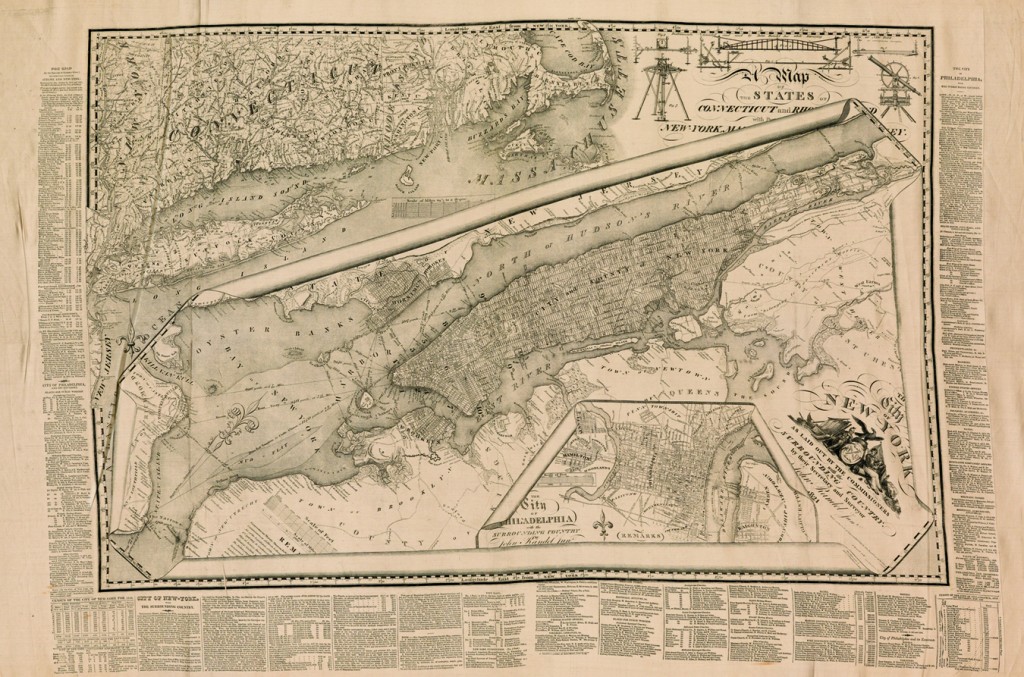
Among the highlights of Swann’s June 6 auction of Maps & Atlases, Natural History & Historical Prints, Ephemera is a Final Commissioner’s Map of New York City by John Randel, Jr., printed on satin, 1821.
As New York City entered the 19th century, it became clear that plans for its expansion northward were in order. The narrow streets from the early Dutch and English settlers could no longer handle the increasing population. This was coupled with an increase in disease spawned by the close quarters of the city.
In 1807 the common council of the city petitioned the state legislature to create a board of commissioners to oversee the layout of a future street system. The board was created and mandated to finalize its plans within a four-year period. Gouverneur Morris, Simeon de Witt, and John Rutherford became the commissioners. Simeon de Witt had been the Surveyor General for the state and had become impressed with the work of one of the surveyors under his charge, namely John Randel.
Randel was hired as chief engineer and surveyor for the city and began his work soon after. Though Manhattan Island was hardly a wilderness, it contained 60 miles of running streams, approximately 20 ponds and lakes, as well as hills, valleys and plateaus. With some surveying instruments of his own devise, Randel set to work. The difficulties of topography were not the only obstacles he was to encounter. Free-holders and lease-holders on the land being surveyed were fearful of losing their land rights. Randel was arrested a number of times for trespassing, and just as many times released on the order of the city council.
Randel finished his project a bit ahead of schedule. The survey overlaid with the now famous grid street plan was ordered to be prepared for publication under the direction of William Bridges. The map was based almost entirely on the survey conducted by Randel, with some additions by Bridges. Peter Maverick, the well-known engraver, was chosen to engrave the map. Randel’s name did not appear on it, and thus began a long and acrimonious relationship between Randel and Bridges. Randel claimed that Bridges had not copied his survey faithfully and that it was full of errors. Randel took charge of the survey and embellished it further. He was set to have it published in 1814 but decided against it–the British had recently burned Washington and Randel feared his map would be too great an aid to the enemy should they decide to attack the city. The manuscript copy of the Randel embellishment is currently under the protection of the New York Historical Society.
In 1821 the finalized version of the map appeared under Randel’s name (indeed, his name appears three times on the map). The grid system begins with 1st street and runs northward to 155th street with the streets running from east to west. It is intersected by 12 avenues running from south to north. It is the city that modern-day inhabitants and the city’s many visitors have come to count on for easy navigation.
The Randel map was printed on paper and very few seem to have been printed on satin. The only other known copy on satin is held by the New York Public Library, gifted by the well-known New York iconographer I.N. Phelps Stokes, who had acquired it from Randel’s nephew. Two paper copies are known.
In addition to the great importance this map bears in its relationship to the mapping of the city, it is a beautiful map to behold. In addition to the grid plan for New York City, there are incorporated maps of parts of Connecticut and Rhode Island as well as an inset of the city of Philadelphia. These are neatly overlaid on one another and with a trompe l’oeil effect they appear to roll in upon themselves.


